

Who will see snow on the ground come Christmas Morning?
Per weather.com and The Weather Channel app data, a “white Christmas” remains most likely in two key regions:
- The northern tier of the U.S., including the Great Lakes, northern Midwest, and parts of the Northeast
- The mountainous West — particularly the Cascades, Sierra Nevada, and northern Rockies — where new snowfall is expected to rebuild recently depleted snowpack
Where snow already stands out
Much of the Midwest and Northeast entered December with unusually strong snow and cold signals:
- Springfield, IL is off to its snowiest winter start since 1893
- Chicago O’Hare has already recorded nearly its full seasonal average
- Cities such as Cleveland, Detroit, and Scranton are experiencing one of their coldest early Decembers on record
What could change by Christmas
The 10-day outlook suggests a shift that may thin snow cover in some areas:
- Warmer-than-average temperatures across much of the Midwest and East
- Cold air largely confined to the northern tier and shorter-lived than recent cold snaps
- Limited new snowfall for the eastern two-thirds of the U.S., aside from areas near the Canadian border and Great Lakes snowbelts
- Continued snowfall across western mountain regions, keeping ski-area snowpack intact
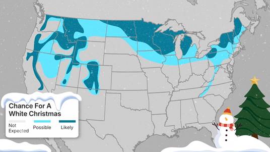
Data: Meteorologists define a white Christmas as having at least 1 inch of snow on the ground Christmas morning.
Regions Most Likely to See a White Christmas:
- Northern tier of the U.S. – including northern Midwest, Great Lakes region, and mountain West.
- Mountainous West – Cascades, Sierra Nevada, northern Rockies.
- Areas with the darkest teal shading on Weather.com’s forecast map indicate the highest probability of ≥1 inch of snow. Light teal shows some chance; gray areas are unlikely.
Current Snow Cover (as of mid-December 2025):
- Midwest & Northeast – significant snowpack:
-
- Springfield, IL: 18.9 inches (snowiest start since 1893)
- Chicago O’Hare: Near full seasonal average snowfall already
- Coldest first two weeks of December on record in cities like Cleveland, Detroit, and Scranton, PA.
10-Day / Short-Term Outlook:
- General warming trend expected across much of the country, especially the Midwest and Northeast → snow cover likely to erode by Christmas.
- Cold fronts will remain mostly in the northern tier and will not persist as long as earlier December cold snaps.
- Eastern two-thirds of the U.S.: minimal new snow expected, except near the Canadian border and Great Lakes snowbelts.
- Western mountains: continued snow expected through Christmas, particularly in Cascades, Sierra Nevada, and northern Rockies where prior snowpack has been depleted.
NOAA 6–10 Day Temperature Outlook:
- Warmer than average temperatures across much of the Midwest and East.
- Colder anomalies primarily in the northern tier states.


