
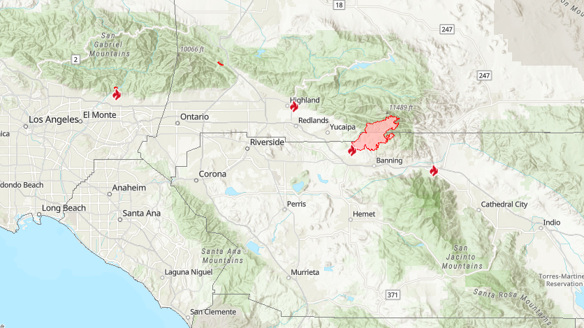
26,450 acres burned in the Inland Empire over the weekend. As of Monday morning, the fire was only 5% contained. Hot and dry temperatures are reported to somewhat improve humidity recovery Monday night. Westerly winds will gust 20 to 30 mph Monday afternoon and evening between 1200 PDT and 2000 PDT, weakening after 2000 PDT but remaining gusty.
The Apple Fire is spreading primarily to the north and east into the San Gorgonio Wilderness. The fire is burning in an area with no recent fire history. It is expected to burn into less dense fuels as it progresses. Fire activity is being driven primarily by record low moisture content of the vegetation combined with high temperatures and low relative humidity. These conditions are contributing to active fire behavior both day and night.
Sunday night and early Monday morning the fire was very active. Multiple spot fires erupted on the north side of the perimeter. The spot fires were engaged by a night vision equipped helicopter. Two of the spot fires were caught but one grew significantly and will be assessed today.
Firefighters are building fireline directly on the fire’s edge where possible. In areas where terrain is too steep to access firefighters are assessing other options for control line. Structure protection is in place in threatened communities. Good progress has been made on the southern and southeastern perimeter. Moving ahead, strategy will include slowing spread to the north and in the San Gorgonio Wilderness. Additional firefighters are arriving on scene to assist with the effort to contain the fire. The assignment of the new resources will give firefighters who have been on the line over the last two days some much needed rest.
Damage assessment teams are deployed and will be surveying the fire area for damage to structures and infrastructure.
Evacuations / Closures:
For Riverside County Residents: please visit https://www.rivcoready.org/ActiveEvents for an interactive map that will allow you to enter your address to see if you are in an evacuation area.
For San Bernardino County Residents: The community of Oak Glen is under an evacuation order. Forest Falls, Pioneertown, and Rim Rock are all under an evacuation warning.
The San Gorgonio Wilderness has been closed to all use. An Emergency Forest Closure Order is in effect as of August 2, 2020. The order prohibits all entry into the San Gorgonio Wilderness and some adjacent areas. This order also includes the Pacific Crest Hiking Trail between the Forest Boundary and Forest Road 1N01. Additionally, all Forest Service recreation areas in the Forest Fall area are closed.
Road Closures:
There are numerous road closures in the area at the following intersections: High & Cherry, High & Jonathan, High & Winsap, Orchard & Avenida San Timateo, Orchard & Avenida Miravilla, Orchard & Oak Glen, Cherry Valley Blvd. & Bellflower Ave., Sunset & Wilson, and Bluff & Mias Canyon.
For more information visit: https://inciweb.nwcg.gov/incident/article/6902/52863/


